Computational modeling of the Zika virus spread: A GIS driven complex adaptive systems approach to modeling the population dynamics of Aedes aegypti
Overview:
Aedes aegypti is responsible for the transmission of several arboviral disases including Dengue, Yellow Fever, Chikungunya and Zika. Understanding the population dynamics of the Aedes aegypti mosquito is, therefore, crucial for the effective deployment of vector control strategies.
Computational modeling has proved to be a success-story in the modeling of mosquito populations in urbanized environments (Focks et al, 1993), where differential equation methods have faltered at capturing the high dimensionality of this problem. Agent-based modeling, in particular, has shown to be highly relatable to modeling mosquito population dynamics (de Almeida et al, 2010; Arifin et al, 2015). Computational decision trees, depicting a mosquitoes daily circadian rhythm and life stages can be embedded within individual agents. Interactions between the simulated agents will then determine the size and distribution of the simulated mosquito population.
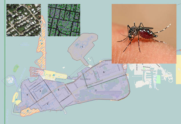
In this project, we have developed an agent-based model of Aedes aegypti (Gunaratne et al., 2016). Our model uses several environmental constraints to estimate the local populace of Aedes aegypti in each neighborhood. The constraints used can be categorized into geographical and climatic constraints. Geographic constraints consist of the locations of nutrition sources and breeding sites. Male mosquitoes depend on vegetation for nutrition and females seek blood meals. Oviposition (laying of eggs) is performed in sites of stagnant water. By applying image segmentation using a k-means classifier on satellite imagery, we could extract the locations of vegetation and urban zones. This layout was then used to create the environment for the agent-based model. We then used house index data from Florida Keys Mosquito Control District (FKMCD) reports to estimate the probability of an urban location to also contain a breeding site (Aedes aegypti prefers to breed near humans) (Hribar & Whiteside, 2010). The mosquito agents were then allowed to move and live upon this simulated environment.
Papers:
GIS Derived Spatial Constraints for Agent-based Modeling
Principal Investigators:
- Dr. Ivan Garibay
Sponsors:
Microsoft Corporation
![]()